Plate tectonic motions are geodynamic phenomena closely related to mass migration inside the Earth, and also an important part of research on geodynamics and global changes. Plate tectonic motions have important influence over the interaction of the various layers of the Earth. It has become hot research topics in modern Earth science to analyze global plate tectonic motions, reveal the law of evolution of specific areas or the Earth as a whole, and predict the trend of motions. Basically, the mass migration caused by plate tectonic motions will inevitably cause small changes in the Earth's external gravity field. The gravity field is one of the inherent physical characteristics of the Earth, which reflects the distribution, movement and the state of change of various geophysical sources. Through differential observations of the gravity field in different periods (including gravity anomalies, gravity gradients, vertical deviations, geoid, etc.), information about the time variation of the global gravity field and its spatial distribution can be obtained. Combined with the theory of plate tectonics, it will provide accurate data for the interpretation and analysis of geodynamic phenomena and geophysical characteristics. The traditional time-varying gravity field is mainly based on GRACE satellite gravity. But as its half-wavelength spatial resolution is about 300-500 km, it cannot accurately measure the ocean floor structures in specific areas and the ocean topography changes.
The Ocean Geodesy and Underwater Navigation research team proposed to use high-precision, high-resolution altimetry gravity fields to construct ocean time-varying gravity fields, and studied the deep-sea tectonic motions based on the correspondence between mass migration and changes of the Earth's external gravity field. They used altimetry data of different periods to calculate the changes of global marine gravity field from 1995 to 2019, and analyzed the characteristics of global submarine plate motions. The results show that the gravity anomalies change significantly at plate convergent boundaries, aseismic ridges, seamount groups and fault zones, but not at plate divergent boundaries. The vertical gravity gradients vary significantly in the Southwest Indian Ridge, Atlantic ridge and Middle Indian Ridge, as well as in the subduction zone of the western Pacific Ocean and some aseismic ridges, which spatial distributions are basically consistent with the terrain. The marine gravity field variations accurately reflected the submarine plate tectonic characteristics on the whole. Compared with gravity anomalies, vertical gravity gradient variations can more demonstrably reflect the submarine plate motions, especially in the mid-ocean ridge. The smaller the spreading rate is, the more significant the vertical gravity gradient variation is.
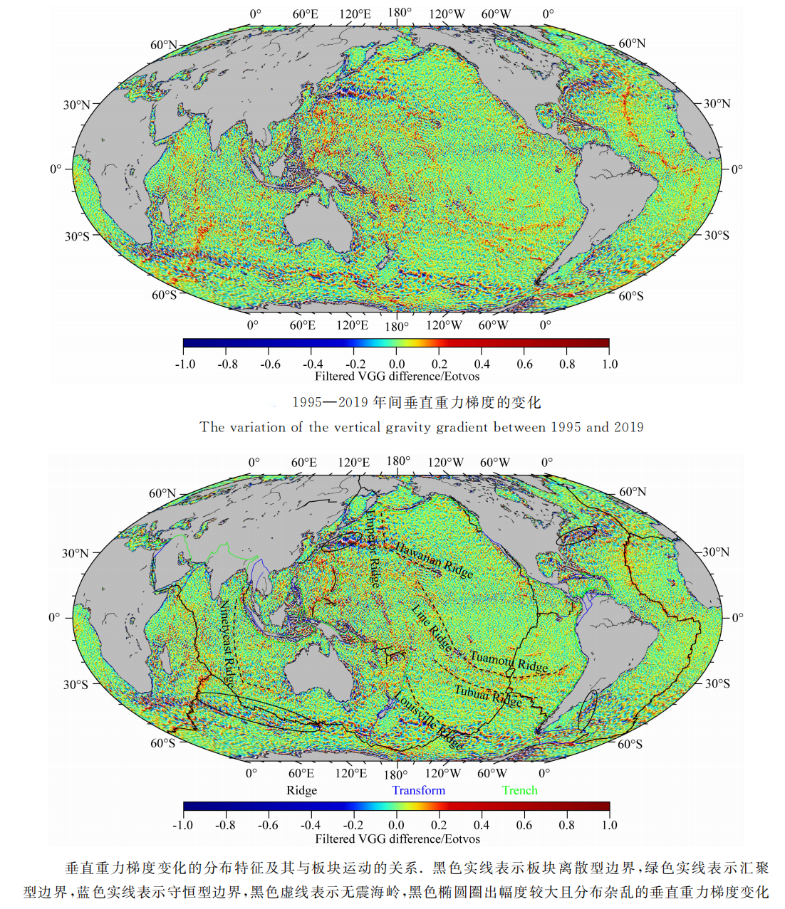
The variation of marine gravity field and plate motions in ocean floor between 1995-2019
"The history of the Earth is the history of volcanoes." The genesis of volcanoes is closely related to plate motions. Discovering volcanoes and understanding volcanoes will help explain the fundamental driving force of plate motions from a scientific perspective, as well as expand the study of mantle convection, mid-ocean ridge, and the cracks and hot spots of continental margins. The particularity of submarine volcanic activity makes traditional volcano monitoring methods inapplicable, and a large number of submarine volcanic activities cannot be accurately measured and understood. In view of the typical regional geodynamic phenomenon of submarine volcanic activity, the research team proposed to use the technical advantages of geodesy in precision and quantification. By a combination of geodesy and repeated observations data of the ocean gravity field through multiple cycles, they detected the rapid mass migration phenomenon of typical regions on the Earth's surface—the characteristics of magma activity during the submarine volcanic eruption. Taking the submarine volcanic activity of Nishinoshima Island in Japan as an example, the research team used DEXP 3D imaging technology to quickly image the distribution of magma inside the volcano, and analyzed the magma movements by comparing the imaging results before, during and after the eruption of the volcano. The research results reveal the complex characteristics of volcanic eruption magma movements, which include lateral magma transports and vertical magma movements. The magma reservoir underlying Nishinoshima appears to be fed via lateral magma transport from the larger, deeper magma chambers located to the east and west sides of the Nishinoshima Island. The direction of lateral magma transport in this area corresponds to the subduction of the Pacific plate westwards beneath the Philippine Sea plate. The enrichment of magma might be due to the addition of HIMU enriched materials (ie., high Nb/Zr and Ta/Hf) in the seamounts on the Pacific plate, which are being subducted westwards beneath the Philippine Sea plate, and the movement of the ocean floor is the main driving force for volcanic eruptions. Vertically, during the active period of volcanic eruption, the magma reservoir in the east changed drastically, especially the magma reservoir in the northeast which decreased notably first and then increased significantly with the volcanic eruption. The depth to the top of magma chamber changed from 1.8 km to 1.4 km, and the final depth was about 1.3 km. The northeast magma chamber is the main source of material for volcanic eruptions. The continuous and significant accumulation of magma means that volcanic activity in this area will remain active in the next few years.
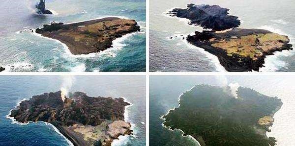
Submarine volcanic eruption and changes of island shape

Inversion of submarine volcanic magma activity image using the anomalies observed in fine-tuned marine gravity
The series of research work in the fine modeling of marine gravity field and ocean floor geodetic observations conducted by the research team involves many disciplines such as geodesy, geophysics, and geodynamics. Their work provides a new route to deepen our understanding of the tectonic characteristics and current state of ocean floor plates, to study the formation process of ocean islands, to interpret the geodynamic mechanisms behind, and to explore more mysteries of the Earth's interior.
This series of studies have been published on Chinese Journal of Geophysics, Journal of Geodesy and Frontiers in Earth Science, with the title of “Altimeter-derived marine gravity variation studies the submarine plate tectonic motions”, “Altimeter-derived marine gravity variations reveal the magma mass motions within the subaqueous Nishinoshima volcano, Izu–Bonin Arc, Japan”, and "Accuracy Evaluation of Altimeter-Derived Gravity Field Models in Offshore and Coastal Regions of China". LI Qianqian, a Ph.D. student from APM, is the first author of the above three articles, and Professor BAO Lifeng is the corresponding author.
The related research is supported by the National Natural Science Foundation of China and the Basic Frontier Science Research Program of Chinese Academy of Sciences.
Full text links:
http://www.geophy.cn//CN/10.6038/cjg2020N0436
https://link.springer.com/article/10.1007/s00190-021-01488-7