The Imaging Geodesy and Geodynamic Processes research team from the Innovation Academy for Precision Measurement Science and Technology (APM) of the Chinese Academy of Sciences (CAS) has recently carried out ground-based survey for Chinese aerial remote sensing system that aims to obtain the Bayi Glacier perspective imaging and tomography data. The team collected data on the subglacial topography and ice cliffs of the Bayi Glacier on the Qinghai-Tibet Plateau, and conducted ground-based observation and calibration of data obtained by airborne P-band synthetic aperture radar (SAR). This survey provided important observation data for the aerial remote sensing experiment on Bayi Glacier organized by the Institute of Tibetan Plateau Research (ITP) of CAS, and provided a valid reference for the precise determination of ice core drilling position in Bayi Glacier to the Northwest Institute of Eco-Environment and Resources (NIEER) of CAS.
APM researcher JIANG Liming organized and formulated the plan for the ground survey, and was invited to guide the demonstration of the aerial remote sensing plan. The Bayi Glacier sky-ground expedition team, formed by APM postdoctor YANG Bo and doctoral students PANG Xiaoguang, LIU Yi, LI Xiao’en, PU Songwen, and WEN Xin, took nearly 20 days to complete ground observation tasks including the layout and positioning of aerial three-dimensional imaging control points and radar corner reflectors, sub-ice topographical surveys by ground-penetrating radar (GPR), and three-dimensional laser scanning on ice cliffs. The team was faced with series challenging tasks. The instruments must be transported to an altitude above 4800 meters to carry out measurements on the steep ice surface. The team made GPS-RTK (global positioning system - real time kinematics) co-site observations of 22 image control points and corner reflectors, and 7 GPR measurements with a total length of over 7 kilometres, and laser point cloud scanning of a one-kilometre-long ice cliff. It was the first time for most team members to climb to such an altitude and they suffered from altitude sickness such as headaches and fevers. However, being excited towards the survey, they overcame difficulties and accomplished all tasks.
From March to April 2023, ITP, together with the Aerospace Information Research Institute (AIRI), APM, NIEER and other institutes, carried out scientific experiment to obtain perspective imaging and tomography data of Bayi Glacier in the Haibei Tibetan Autonomous Prefecture in northwest China's Qinghai Province, which locates in the upper reaches of the Heihe River. The experiment used the Xinzhou-60 airplanes with radars in P-band and L-band, laser radar, high-resolution linear-array digital aerial camera for remote sensing. Meanwhile the ground-based observation and calibration of SAR data was conducted. Low-frequency SAR is a new approach to finely reconstruct the subglacial topography of the Qinghai-Tibet Plateau. It can see through ice and snow and image the internal structure of glaciers in three dimensions. This aerial remote sensing experiment provides important reference for Chinese P-band cryosphere satellite plan demonstration.
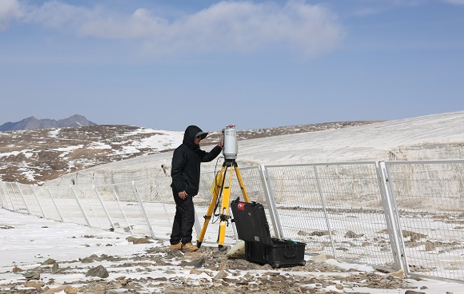
The research team used terrestrial laser scanner (TLS) to scan the ice cliff
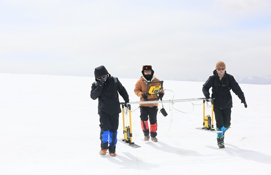
The research team used ground-penetrating radar to survey subglacial topography