The Environments and Disaster Monitoring and Evaluating Research Team of the Innovative Academy for Precision Measurement Science and Technology (APM), collaborating with the University of Nottingham in the UK, has made new progress in surface water dynamic monitoring with multi-source remote sensing data. The research was recently published in Remote Sensing of Environment, which is a top academic journal in the field of remote sensing.
Accurately monitoring the dynamic changes of surface water with high temporal and high spatial resolution is essential for understanding global ecosystems and climate change. Satellite remote sensing, as an important means of earth observation, provides the main data sources for monitoring large-scale surface water dynamics. However, there is often a tradeoff between the spatial and temporal resolutions of imagery acquired from current satellite sensors. Currently, the European Commission's Joint Research Centre and the Global Land Analysis and Discovery Laboratory of the University of Maryland have used Landsat satellite remote sensing images with 30 m resolution at a 16- day time step to monitor the dynamic of global surface water. However, related researches are challenging to monitor water changes which are relatively abrupt in situations such as flooding, and the monitoring is affected by satellite image striping and cloud/shadow cover that result in no-observation data in many areas.
In order to monitor high spatiotemporal water dynamics from remote sensing, the research team proposed a new method based on the Landsat remote sensing images, by fusing 500-meter resolution/8-day MODIS composite images. Meanwhile, considering that the spatial distribution of surface water is often controlled by topographic conditions, the proposed method also used the surface water occurrence data and the digital elevation model to provide, respectively, topographic information below and above the water surface. A local spatial filtering was used to help map surface water under clouds. This proposed method was used to generate an 8-day time series surface water maps of 30 m resolution in six inundation regions globally, and can predict the presence of surface water even for cloud pixels in the MODIS image, thus providing a promising way for accurately understanding the surface water dynamics.
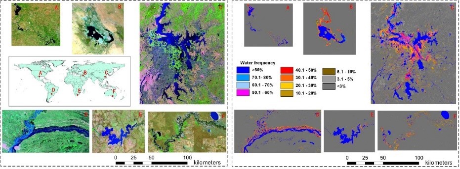
Satellite remote sensing images of study regions (left) and surface water frequency map extracted by the research (right)
The research, with the title of "Monitoring high spatiotemporal water dynamics by fusing MODIS, Landsat, water occurrence data and DEM", was published in Remote Sensing of Environment, which is a top academic journal in the field of remote sensing. APM Professor LI Xiaodong is the first author and corresponding author.
The research was jointly funded by the National Natural Science Foundation of China, the Youth Innovation Promotion Association of the Chinese Academy of Sciences, and the Application Foundation Frontier project of Wuhan, etc.
Full text link: https://www.sciencedirect.com/science/article/pii/S0034425721004004