A research team led by JIANG Liming of the Innovation Academy for Precision Measurement Science and Technology (APM), in collaboration with the Aerospace Information Research Institute and the Institute of Tibetan Plateau Research, conducted comprehensive observations of Bayi Glacier using ground-penetrating radar (GPR) and aerial remote sensing. This study reconstructed detailed surface elevation and subglacial topography characteristics, quantitatively assessed the volume of Bayi Glacier, and analyzed how climate change influence variations in its area, thickness, and volume. The new results were recently published in the Journal of Hydrology: Regional Studies. It is worth noting that the last significant findings from the joint expedition to the Bayi Glacier with the two institutions were published in the ISPRS Journal of Photogrammetry and Remote Sensing early in this year.
Bayi Glacier, located in the western Qilian Mountains, is the largest glacier at the headwaters of the Heihe River, which is the second-largest inland river in the northwest China. However, over the past 17 years, climate change has accelerated glacial melting, threatening the hydro-ecological security of the Heihe River basin. Therefore, accurately quantifying Bayi Glacier’s volume, analyzing its change characteristics, and identifying influencing factors are therefore critical to assessing both current and future glacial dynamics and their influence on regional water resources. During a March 2023 field expedition, the research team deployed "Modern Ark 60" remote sensing aircraft equipped with LiDAR and SAR instruments, marking the first use of this platform for glacial surveys. Combined with ground control point calibration, this study captured high-resolution, high-precision glacier surface elevation. GPR measurements also meticulously delineated the glacier’s distinctive "W-shaped" subglacial topography. Integrating satellite remote sensing and meteorological data, researchers analyzed changes in the glacier’s area and volume alongside contributing factors.
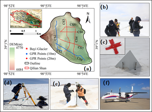
Figure (a) shows the location of the Bayi Glacier and the tracking of GPR measurements. Figures (b)-(e) depict ground-based measurements, and Figure (f) illustrates the Modern Ark 60 remote sensing aircraft
The study revealed that Bayi Glacier’s area shrank from 2.68 km2 in 2006 to 2.36 km2 in 2023, a 12.17% reduction equivalent to losing 2.7 standard soccer fields annually. Average ice thickness decreased from 54.2 m to 45.16 m, with the thickest section thined by 12.5 m. Glacier volume plummeted from 0.153 km³ to 0.1065 km³, a sharp decline of 30.39%, representing an ice loss equal to 3.2 times the volume of West Lake. Cross-sectional data further identified two "Overdeepening" zones (Figure a-d). These changes correlate with a 0.15℃/year summer temperature rise and a 2mm/year decline in solid precipitation, which diminishes the glacier's accumulation. Increased liquid summer precipitation also intensifies evaporation, creating a "melting-evaporation" feedback (Figure e-h). These findings highlight the value of integrated aerial-ground observations in glaciology. The high-precision glacier thickness and subglacial topography data observed in this study provide a critical foundation for calibrating ice thickness models and projecting future glacial evolution.
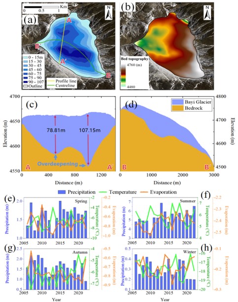
Figure (a) displays the reconstructed ice thickness distribution; Figure (b) shows the subglacial topography; Figures (c)-(d) present the cross-sectional profiles of the glacier in the transverse direction and along the centerline, respectively; Figures (e)-(f) illustrate the seasonal climatic characteristics of the glacier area, respectively
The study, titled "Mass loss of Bayi Glacier in the Heihe River Basin revealed by ground-penetration radar measurements from 2006 to 2023" was published in Journal of Hydrology: Regional Studies, with APM as the lead institution. Professor JIANG Liming served as the corresponding author, and doctoral student PANG Xiaoguang as the first author.
This research received joint funding from the National Natural Science Foundation of China (NSFC), the National Key Research and Development Program of China, and the Key Program of the Natural Science Foundation of Hubei Province.
Link to the article: https://doi.org/10.1016/j.ejrh.2025.102255