Recently, the imaging geodesy research team from the Innovation Academy for Precision Measurement Science and Technology (APM) took Hengshui City, Hebei Province as a case study. By employing the Time-Series Interferometric Synthetic Aperture Radar (TS-InSAR) technology, they conducted an in-depth analysis of the relationship between excessive groundwater exploitation and land subsidence. Relevant research findings were recently published in the Journal of Hydrology: Regional Studies.
The North China Plain is one of the three major plains in China. It is the most populous plain in China, and its economic development mainly relies on groundwater support. Groundwater over-extraction is associated with land subsidence, posing challenges to the ecological environment and infrastructure. In light of this current situation, taking Hengshui City, where the subsidence issue is prominent, as a typical area, studying the causal relationship and spatio-temporal characteristics between groundwater extraction and land subsidence is of vital importance for sustainable water resource management.
The study, based on Sentinel-1A SAR satellite data (Figure 1), employed the TS-InSAR technique to acquire high-precision surface deformation information of Hengshui City from 2017 to 2024. Through the processing of key technologies such as seasonal subsidence signal separation and phase lag correction, and by combining with groundwater dynamic monitoring data, the relationship between groundwater level changes in the confined aquifer and land subsidence in the study area was systematically analyzed.
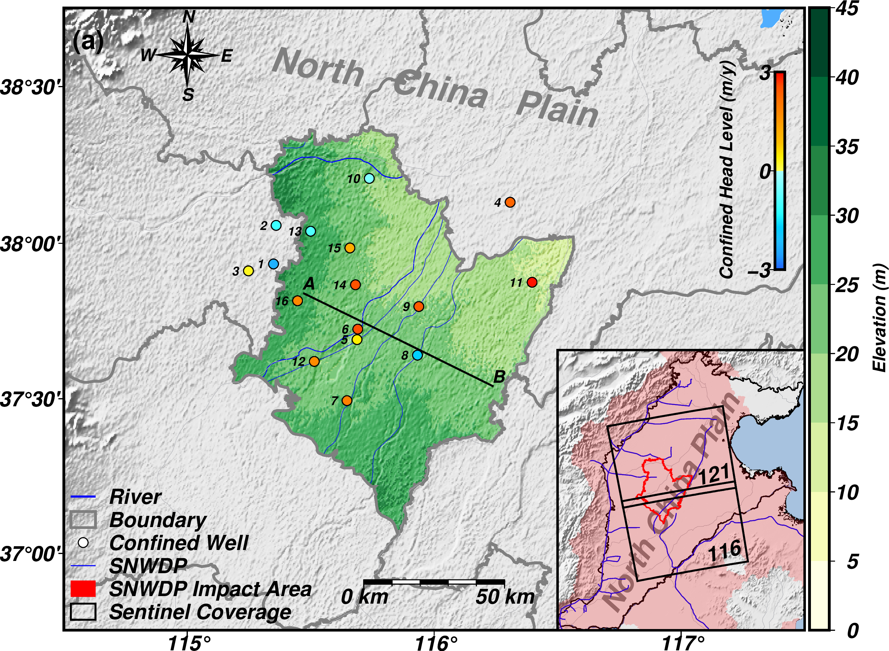
Location of the study area (including regional geological characteristics, the number of confined-water wells, and the coverage area of Sentinel satellite data)
The study found that land subsidence in Hengshui City exhibited two typical characteristics (Figure 2): The first type showed a significant synchronicity between the subsidence rate and the dynamic changes of groundwater levels, indicating that the main controlling factor for its subsidence was the water level decline in the confined aquifer system. The second type displayed an abnormal phenomenon where subsidence continued to develop against the backdrop of groundwater level recovery. After analysis, it was mainly attributed to the hysteretic drainage effect in the aquitard triggered by the previous water level decline. The study further revealed that Hengshui City is located in a special geological environment at the transitional zone between the Yellow River alluvial plain and the alluvial fan, and there exists significant spatial heterogeneity in the lithological composition and structural characteristics of the sediments. This geological background results in the regional aquifer system exhibiting strong heterogeneity in terms of water-storage capacity and permeability, thus forming an uneven spatial distribution pattern of land subsidence.

Time series of deformation and hydraulic head near the four groundwater level monitoring points
During the period when the national "South-to-North Water Diversion" strategy is being continuously advanced and the governance of groundwater over-exploitation areas has entered a crucial stage, this study provides new insights into the monitoring of groundwater changes in Hengshui City. These insights can be used to constrain groundwater and subsidence models, offering important scientific bases for regional groundwater management and land subsidence prevention and control. In addition, the study also demonstrates the strong application potential of TS-InSAR technology in groundwater research. It can carry out wide-area deformation monitoring with millimeter-level measurement accuracy, providing an efficient tool for the correlation analysis between surface deformation and groundwater dynamics. The relevant research methods are not only applicable to Hengshui City, but can also serve as a reference for studies in other regions of North China and other over-exploitation areas across the country. In the future, by integrating more monitoring technologies (such as GRACE gravity satellite data), it is expected to further enhance the accurate assessment of groundwater storage changes.
The related achievements, titled "TS-InSAR assessment of groundwater overexploitation-land subsidence linkage: Hengshui case study", were published in the Journal of Hydrology: Regional Studies. AN Yan, a Ph.D. student from APM, is the first author of the paper, and SHEN Qiang, a researcher, is the corresponding author.
This research was partially funded by the National Natural Science Foundation of China, the Wuhan Natural Science Foundation, and the Open Fund of Luojia Laboratory in Hubei Province.
Link to the article: https://www.sciencedirect.com/science/article/pii/S2214581825003143